|
Acoustic Instrumentation for Imaging & Quantifying Seafloor Hydrothermal Flow
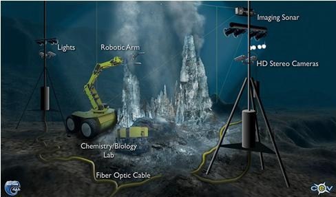
Image provided courtesy of the NEPTUNE Project(www.neptune.washington.edu) and Center for Environmental Visualization, University of WashingtonOur goal is to provide a near real-time user-friendly data product for the deep sea research community, which will include automated signal processing for the large data acquisition rates anticipated, and will apply our proven methods to measure 3D geometry, flow rate and volume flux of buoyant plumes and area of diffuse flow. We use acoustics in coordination with visualization and quantification methods to image and measure smoker-type plumes in 3D and to map diffuse flow in 2D. The plumes originate as clear, hot (c. 150° to 400°C) solutions that vent from mineralized chimneys, precipitate dissolved metals as they mix with ambient seawater, and buoyantly rise up to hundreds of meters. The seepage discharges as clear diffuse flow at lower temperatures (<150°C) from networks of fractures at the rock/water interface and may be entrained into plumes or disperse in discrete layers. These flow regimes are being intensively studied for their role as agents of transfer of heat, chemicals and microbes from the lithosphere into the ocean that globally influence seawater composition, cool the Earth, contribute to climate change, concentrate metallic mineral deposits, and support chemosynthetic ecosystems.
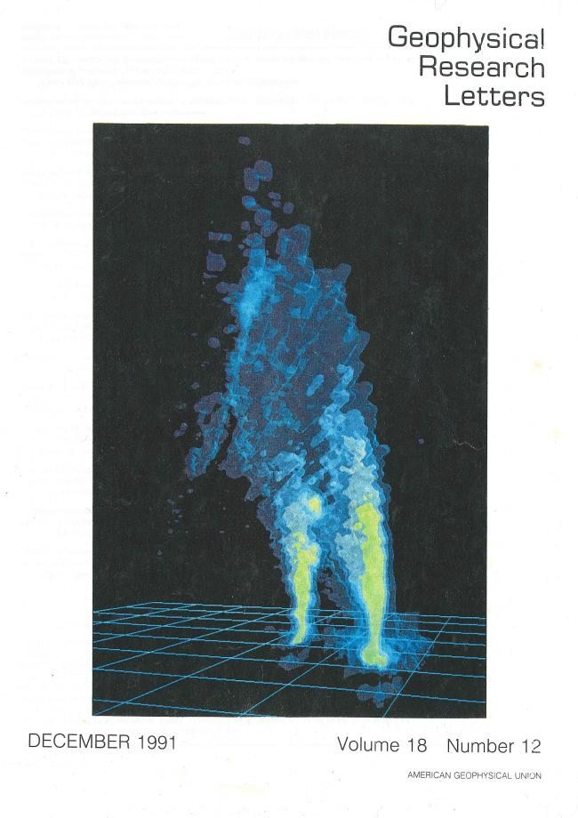
Three-dimensional reconstruction of an acoustic image of the lower 40m of two buoyant plumes discharging from adjacent black smoker vents at a depth of 2635m on the East Pacific Rise near 21°N, 109°W (5x5x5m rectilinear grid). The image was made from a digital data set of acoustic backscattering information recorded with a specially modified submersible-mounted sonar system. The reconstructed image shows multiple zones of flow organization, coalescence of the two plumes, and bending of the coalesced plumes in the direction of the prevailing oceanic current (north). The newly developed acoustic imaging technique is providing information on the volume and structure of hydrothermal plumes on a time scale suitable for determination of plumes on a time scale suitable for determination of plume dynamics and monitoring. (Click here to see article by Rona et al. December 1991)Our team works on each of the following modules of the whole project:
1. Acoustic Data Recording and Collection
2. Signal Processing
3. Visualizing Acoustic Data
4. Analysing and Quantifying the Visualized Data
5. Plume Modeling
© RUTGERS, The State University of New Jersey. All rights reserved.